Inside the slums and gated communities the opportunities and obstacles to sustainable and inclusive urban development can be seen.
Spending a few days in Delhi as part of the Sustainable, Healthy and Learning Cities and Neighbourhoods project has given me insights into the way urbanisation is taking place in the city, and the implications this has for urbanisation more generally. Work done by researchers from the National Institute of Urban Affairs, the Indian partner in the project has helped my understandiing, though all opinions expressed in this blog are my own.
From the Raj to Modi
Delhi has become one of the largest cities in the world. with a population put at more than 16 millions. Its origins far predate the era of British colonialism. The walled old city remains at the core, while the Mughals, who ruled for three centuries, stamped an enduring mark on the built environment. However, my hotel is in New Delhi, the area planned on classic colonial lines under the British Raj. In 1911, the British decided to move the capital of India from Calcutta to a more central location. Famously, the plan for New Delhi by Lutyens and Baker created spaces for monumental neo-classical buildings within a highly geometrical street pattern of circles, radial connectors and grand vistas. The national institutions of modern, independent India stand proudly here today: the domed and colonnaded Viceroy’s House is now the official residence of the President. The colonial plan also provided for bungalows set in extensive grounds; today these are where Indian MPs and other high ranking people like judges live.
The New Delhi designed over a century ago remains intact. Notwithstanding a few high rise hotels, it is an area of trees and greenery, and by 21st century metropolitan standards low rise buildings; though traffic congestion exceeds anything imaginable in the early 20th century. The area must be one of the world’s major commercial development opportunity sites, but also it is home to the world’s most powerful potential NIMBYs! In September 2019 the Indian government announced its intention to redevelop a 3 km stretch, the Central Vista, from the President’s House to the iconic war memorial arch at India Gate. This „dream of President Modi“ has attracted bids from six firms of consultants. It remains unclear which historic buildings will be demolished, while the declared intention is to bring together different government departments that are currently scattered. As a taster of what might happen, the Minister responsible has stated that no tree will be cut down and „The green cover will be multiplied 10 times“. Widespread public consultation is also promised. The target is to get the redevelopment finished by 2022. This is one to watch in the coming months.
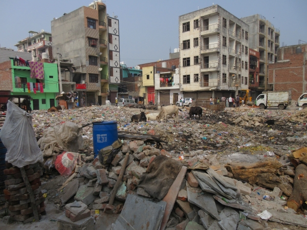
A slum resettlement colony
Through the kind introduction by World Vision India, our international group was able to make a study visit to the one of the city’s Slum Resettlement Colonies. There are over 50 such neighbourhoods in Delhi, and around 10% of the city’s population live in them. Since the 1970s at least, there has been an active policy of eviction and relocation of people from areas of unauthorised informal housing. Readers with long memories may recall that there was much criticism of this policy when slum areas were being cleared for the 2010 Commonwealth Games. As far as I can understand the Delhi Develoment Authority (DDA), a central government agency, which is a major land owner with strong land assembly powers, makes a resettlement site available, often at the edge of the city. Sites are then developed within set standards for housing, roads, public space and some basic infrastructure. Initlal residents get a license in exchange for a fee, giving them what is in theory a kind of non-transferable leasehold, though in reality there is a market in such rights.
The Mandanpur Khadar Colony visited by the SHLC research team was developed on a site that had previously been an unauthorised informal settlement. So one set of slum dwellers were shifted to make way for a semi-formalised and planned district for evictees from slums. The part of the Colony that I walked through revealed that though some properties certainly started off as single storey, many were being extended vertically, as the picture shows: I saw a man laying bricks on his roof to add a second storey. Yards selling building materials such as cement are to be found near the shopping areas. Rather like in China’s urban villages, or in Cape Town’s back shacks, entrepreneurial residents or landlords have been able to create income flows from rents through densification. There is some provision of sewerage, but also open drains. Water supply is a problem: many properties have water tanks on the roof, connected to underground natural water supplies, but drinking water is purchased from hawkers with handcarts. Formal collecton and disposal of solid waste seems non-existent.
Ground level flats are also used as shops, and the streets are alive, not only with people (and cows) but with a plethora of small traders pushing their wares on carts. However, the location of the Colony is problematic: it is distant from major employment centres, and is unserved by mainstream public transport (though there are numerous private rickshaws and taxis). It is also close to a power station that augments the health risks from the poor air quality that engulfs the Indian capital. Lack of safe public transport particularly restricts the chances of women to access jobs elsewhere. A women’s co-operative saving bank has shown how small scale, bottom-up initiaitives can succeed. Weekly deposits enable members to borrow at low interest rates when need or opportunity arises. We met a young woman who had been a school dropout but was now running a beautician business and a couple of small shops.
A smart, sustainable neighbourhood – restricted access
Finally we visited a major green building / smart city technology mixed use scheme constructed by NBCC, a state enterprise. Over 20,000 people live in a gated community that was developed on a site that previously was used for much lower density housing for public servants. Employment-linked housing for public sector workers is not uncommon in former British colonies. The Green View development boasts sophisticated sanitation systems and all kinds of digital technologies, with a central monitoring and control unit able to check out just about everything happening in the development, down to individual flats. There are a couple of metro stations, one at either end of the development.
This high-end, planned urban hub is exclusively for public employees, with the allocation of flats and even parking spaces dependent on the grading of the job. Retirement means that you have to leave, just as the death of the resident employee results in the surviving non-employee members of the family also having to quit their home.
Lessons
The City Beautiful ethos bequeathed by Lutyens and the British colonial planning system from the early 20th century remains imprinted on urban planning in Delhi. Evictions of poor people from their informal settlements is common, and justified by the idea of keeping the city clean. While the inventiveness and entrepreneurialism of many of these people is admirable, typically they are relocated to sites that are far away from the places where they made their livelihoods. The contrast with the state provided housing for those lucky enough to get a job in a public service body is stark. Putting into practice the language of green planning is fine, but that practice here in Delhi is also exclusionary. We need to ask who „sustainable urban development“ is for. The British colonists planned green and leafy enclaves that distanced them from the poor: a similar 21st century model of spatial inequality is being created.
Schreibe einen Kommentar